Simulating Sea Lion The South East of England in 1940
Early September Update:
After a few months of working on London 1940, I realized most of the interest/development is still in simulating Sea Lion. So this project web-page will be updated with the project's developments.
The source code and general ideas will be maintained through https://london1940.org. In particular:
open source football hooligan simulator: currently represented in the war source - urbanwarplanet
Latest video on the progress of the data - early April
Aim
Sim Sea Lion simulates 100 miles by 100 miles of the area around the South East of England including London in 1940.
Secondary aims of the simulation include the potential to simulate Germany's invasion of the South East of England during the Battle of Britain in the Second World War.
Development
The simulation is developed from the ApeSDK's Urban and War simulations (now combined into urbanwarplanet).
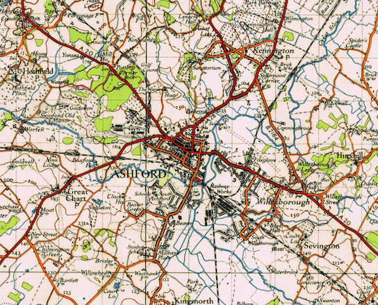
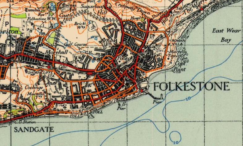
Interpreted map data coming from the Ordinance Survey maps of 1940 from the National Library of Scotland which thankfully is free to use for this kind of work. It represents roughly 100 miles by 100 miles of very varied map data including buildings, rail, road, waterways, and orchards.
urbanwarplanet - combines the urban simulation and the war simulation for a realtime interface for map editing.
map - creates map2json which converts the PNG files to JSON files and contains the five towns of initial interest. Also contains all the automation testing around the JSON output files. In particular can they be quickly read by the ApeSDK.
Also includes drawout takes the ApeSDK compatible JSON file and generates a map showing the details captured in the JSON from the original map PNG.
southeastengland1940maps - contains the original full resolution Ordinance Survey maps for the area.
The source is licensed under the ApeSDK license (a version of the BSD license (BSD-1-Clause + Joke)).
We are very close to getting the data-set into an agent simulation and are looking for agent modellers who are interested in this problem space.
Initial Simulations
The initial aim of the project is to simulate the land warfare including aerial bombing Ashford, Kent.
The secondary aim is to simulate the land and sea invasion of Folkestone, Kent.
It is projected another location may be simulated such as Canterbury, Southend-on-Sea or Maidstone before the broader simulation of the land and sea invasion of London is undertaken.
This web page will serve as a location for temporal updates of information. All email correspondence can be directed to Tom Barbalet barbalet at gmail dot com.